
GIS mapping enlists technology in the quest to reunite lost pets with their people
July 26, 2023
The next time someone calls your shelter about their lost cat or walks into the lobby with a stray dog, how cool would it be to direct them to a map showing every animal who was lost or found near their location? How much easier would life be for your animal services officers if they could use such a map to make more returns in the field? And wouldn’t that kind of visual tool simplify decisions about how to distribute resources for things like trap-neuter-vaccinate-return (TNVR)?
If your answers are “it would be really cool,” “that sounds a lot easier,” and “um, duh it would!”, then it’s time to investigate a geographic information system (GIS). According to software company Esri,
GIS is a system that creates, manages, analyzes, and maps all types of data. GIS connects data to a map, integrating location data (where things are) with all types of descriptive information (what things are like there). This provides a foundation for mapping and analysis that is used in science and almost every industry. GIS helps users understand patterns, relationships, and geographic context. The benefits include improved communication, efficiency, management and decision-making.
All you need to know, however, is that GIS can streamline processes, improve efficiency, increase positive outcomes, strategically disperse resources, fine-tune decision-making, and make work at your shelter easier for everyone. Best of all, there are enough options out there to fit the needs and budgets of any organization.
Visualizing lost and found animals
Everything from binders kept at shelters to postings on social media to national sites like Paw Boost and Petco Love Lost are available to those who have lost a pet or found one. Trying to reunite wayward dogs and cats with their people can be notoriously difficult, however, and is one reason why more shelters are adding GIS to their arsenal. For some, like Matt Madcharo, executive director at Capital Humane Society (CHS) in Lincoln, Nebraska, GIS offers a distinct advantage over more old-school methods.
“I can think of four or five different Facebook group pages serving our area, plus there are listings on Nextdoor,” Matt says. “I find it’s just hard to find anything when you have to scroll through so many social posts, especially compared to having a central place where all the information is easily accessible.”
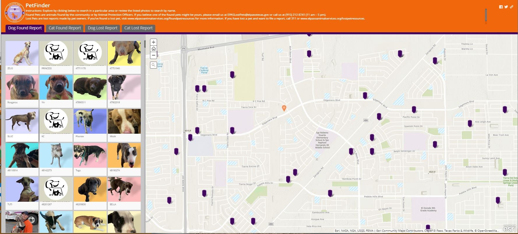
When Matt first saw the GIS map used by City of El Paso Animal Services in Texas, he knew it could be the solution he’d been looking for. Katie Pemberton, marketing and communications supervisor at Memphis Animal Services (MAS) in Tennessee, also found inspiration in a map used by Maricopa County Animal Care and Control in Arizona.
“When I saw the map during a conference presentation, I thought it was coolest thing ever,” says Katie. “I connected with the person working on the project and asked the GIS team in the city’s information technology department if it was something they could replicate for us. They not only said yes, but they were also really excited about it.”
More than just putting lots of information in one place, there's something about being able to visualize the distance an animal may have traveled that really resonates with people. MAS also put markers on its map for all fire stations, vet clinics, and shelters equipped with microchip scanners so people can check found animals for identification.
“Our goals with this system are to provide our community with better service and support during a time when people are often panicked,” says Alex Eley, pet reunification specialist at MAS. “We hope that having the locations of microchip scanners on there as well will help increase the community pet reunification rate, which is already a lot higher than the return-to-home rate for cats and dogs who come into the shelter.”
Guiding officer strategies
In addition to giving the public better tools, the map is a valuable resource for field officers. Being able to zoom in on the location where they are picking up free-roaming animals is much simpler and less time-consuming than scrolling through a database.

“There are specific geographic areas where officers are more likely to encounter stray animals and areas where in-field return-to-owner rates are higher,” says Quinn Sweet, program coordinator at Washoe County Regional Animal Services (WCRAS) in Nevada. “We have been discussing using mapping systems to improve services for several years, because we wanted a formal method to understand data-backed geographic differences in our population. With GIS, we can focus patrols, education, and outreach to specifically identified areas, but we’ve only just begun to scratch the surface on how we plan to use it to better support the community.”
Mapping community cat efforts
Karen Little, founder of Alley Cat Advocates (ACA) in Louisville, Kentucky, began using Google Maps in 2010 to support a grant from PetSmart Charities and make sure their targeted trapping was effective.
“You can actually see how much progress has been made in the community through our efforts,” she says. “We also have tabs on colony size based on where we’ve spent a lot of time supporting TNVR. The map makes it easy for us to see where our limited resources are most in need.”
They also use the maps on an almost daily basis for a variety of purposes related to TNVR work and community cat management. The technology allows them to quickly tap into records of every caregiver who has accessed spay/neuter or trapping services so they can help members of the public when they call about specific colonies.
“Caregivers who have been caring for some cats in their backyard sometimes call us because they are going to be moving and they are worried about the cats’ welfare,” Karen says. “By going to our map, we can reassure them when someone feeds nearby because typically their cats know about that feeding station and spend a good amount of time there, too. It gives them piece of mind and those cats don’t end up being unnecessarily relocated.”
Talking technology
 Though it might sound intimidating, it is easier than ever to visualize location-based data through a variety of apps geared to a range of skillsets. Karen prefers Google Maps because, as she explains, “you don’t need an expert to figure out the tool.
“If you can put names and addresses in an Excel spreadsheet, you've got all you need,” she says. “Taking 30 minutes to upload an Excel spreadsheet into a map takes a little time, but it’s not wasted time. It’s work that will help you in the long run, more than you can imagine.”
There’s also no need to start from scratch, a lesson that Memphis and Capital Humane learned by basing their maps on what they saw being used in other cities and by talking with those shelters.
“The whole reason we have a map is because I saw Maricopa’s at an animal welfare event,” Katie says. “Conferences, town halls, and webinars are valuable because they are opportunities to find out what other organizations are doing. Those organizations are typically happy to walk you through exactly how they did it. You can prevent a lot of headaches by copying what is already proven.”
Measuring impact
As for the ultimate impact GIS will have on a shelter’s operations, including increased RTO rates and streamlined processes, the early feedback is promising.
“Tracking the impact of using the map is something I would like to work on a little more, but we've gotten a lot of positive feedback from the community,” says CHS’s project development coordinator Jacob Biaggi. “We’ve heard from people who have gotten their pets back as well as some who found an animal’s owner using the map. And about three months after we made our map live, one popular lost and found group on Facebook decided to stop posting such listings to focus on other animal issues. They direct people to our map now instead.”
Based on that success and the internal benefits of using the technology, Jacob strongly encourages shelters to think about diving into the world of GIS.
“Shelters need to be proactive and explore what’s out there that can make things more efficient, not only within the shelter but also in the community,” he says. “Animal welfare has always been playing catch up when it comes to technology, and it’s more important than ever to invest in ways to get every resource into people’s hands. That includes GIS.”
Some GIS options:

Liz Finch
Senior Writer
Best Friends Network
If you enjoyed this program spotlight, you can find our complete catalog of spotlights here.